Difference between revisions of "San Jose road"
(Created page with "http://www.parks.ca.gov/pages/1054/files/Mission_District_context_111607%20(2).pdf https://www.glenparkhistory.org/the-old-mission-road-in-glen-park https://default.sfplanning.org/Preservation/South_Mission/Juri_Street_comp.pdf The San Jose road was Mission road and El Camino Real. The article CHAT ABOUT THE CYCLE. - San Francisco Call - May 9, 1892 describes a start from the Bay City Wheelmen club house at [https://goo.gl/maps/UwGv6MASFrqBMaCg6 443 Go...") |
|||
| Line 5: | Line 5: | ||
https://default.sfplanning.org/Preservation/South_Mission/Juri_Street_comp.pdf | https://default.sfplanning.org/Preservation/South_Mission/Juri_Street_comp.pdf | ||
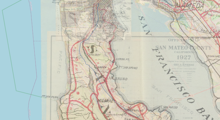
The [[San Jose road]] was [[Mission road]] and El Camino Real. The article [[CHAT ABOUT THE CYCLE. - San Francisco Call - May 9, 1892]] describes a start from the [[Bay City Wheelmen]] club house at [https://goo.gl/maps/UwGv6MASFrqBMaCg6 443 Golden Gate Avenue], near Van Ness Avenue, proceeding south to Market, then Valencia, then the [[San Jose road]] to [[San Mateo]]. They could have taken the [[San Bruno road]], which we now call Bayshore Blvd, but didn't. Here is an imperfect rendering of the route they took, using [https://qgis.org/en/site/ QGIS] software, and these maps from the David Rumsey collection; [https://www.oldmapsonline.org/maps/6f4796ba-b36e-5a1e-9bdb-10dce6d39c99/ 1891 Guide Map Of City And County Of San Francisco], [https://davidrumsey.oldmapsonline.org/maps/17b06ed2-06b9-5673-9553-e7ae07a9bd5d/ 1896 San Mateo, Santa Cruz, Santa Clara, Alameda, and Contra Costa Counties.] (From the [https://www.davidrumsey.com/luna/servlet/detail/RUMSEY~8~1~1574~170042:Cover--California-cyclers--guide%2C-r?sort=Pub_List_No_InitialSort%2CPub_Date%2CPub_List_No%2CSeries_No&qvq=q:cyclers;sort:Pub_List_No_InitialSort%2CPub_Date%2CPub_List_No%2CSeries_No;lc:RUMSEY~8~1&mi=0&trs=11 The Cyclers' Guide and Road Book of California]) and [https://www.oldmapsonline.org/maps/cfc8dd79-80c6-439f-8a18-fd59873a4f93/ 1927 Official Map of San Mateo County California]: | The [[San Jose road]] (blue line) was [[Mission road]] and El Camino Real. The article [[CHAT ABOUT THE CYCLE. - San Francisco Call - May 9, 1892]] describes a start from the [[Bay City Wheelmen]] club house at [https://goo.gl/maps/UwGv6MASFrqBMaCg6 443 Golden Gate Avenue], near Van Ness Avenue, proceeding south to Market, then Valencia, then the [[San Jose road]] to [[San Mateo]]. They could have taken the [[San Bruno road]], which we now call Bayshore Blvd, but didn't. Here is an imperfect rendering of the route they took, using [https://qgis.org/en/site/ QGIS] software, and these maps from the David Rumsey collection; [https://www.oldmapsonline.org/maps/6f4796ba-b36e-5a1e-9bdb-10dce6d39c99/ 1891 Guide Map Of City And County Of San Francisco], [https://davidrumsey.oldmapsonline.org/maps/17b06ed2-06b9-5673-9553-e7ae07a9bd5d/ 1896 San Mateo, Santa Cruz, Santa Clara, Alameda, and Contra Costa Counties.] (From the [https://www.davidrumsey.com/luna/servlet/detail/RUMSEY~8~1~1574~170042:Cover--California-cyclers--guide%2C-r?sort=Pub_List_No_InitialSort%2CPub_Date%2CPub_List_No%2CSeries_No&qvq=q:cyclers;sort:Pub_List_No_InitialSort%2CPub_Date%2CPub_List_No%2CSeries_No;lc:RUMSEY~8~1&mi=0&trs=11 The Cyclers' Guide and Road Book of California]) and [https://www.oldmapsonline.org/maps/cfc8dd79-80c6-439f-8a18-fd59873a4f93/ 1927 Official Map of San Mateo County California]: | ||
[[File:CHAT ABOUT THE CYCLE. - San Francisco Call - May 9, 1892 map 75dpi.png|thumb|center|700px|The [[San Jose road]], as described in [[CHAT ABOUT THE CYCLE. - San Francisco Call - May 9, 1892]]. A 300 dpi version of this file can be viewed or downloaded [https://drive.google.com/file/d/1uKHLyXIwQeXhEbzW5MrfdKJ5GNdeLI9c/view?usp=sharing here].]] | [[File:CHAT ABOUT THE CYCLE. - San Francisco Call - May 9, 1892 map 75dpi.png|thumb|center|700px|The [[San Jose road]], as described in [[CHAT ABOUT THE CYCLE. - San Francisco Call - May 9, 1892]]. A 300 dpi version of this file can be viewed or downloaded [https://drive.google.com/file/d/1uKHLyXIwQeXhEbzW5MrfdKJ5GNdeLI9c/view?usp=sharing here].]] | ||
Latest revision as of 23:12, 11 July 2023
http://www.parks.ca.gov/pages/1054/files/Mission_District_context_111607%20(2).pdf
https://www.glenparkhistory.org/the-old-mission-road-in-glen-park
https://default.sfplanning.org/Preservation/South_Mission/Juri_Street_comp.pdf
The San Jose road (blue line) was Mission road and El Camino Real. The article CHAT ABOUT THE CYCLE. - San Francisco Call - May 9, 1892 describes a start from the Bay City Wheelmen club house at 443 Golden Gate Avenue, near Van Ness Avenue, proceeding south to Market, then Valencia, then the San Jose road to San Mateo. They could have taken the San Bruno road, which we now call Bayshore Blvd, but didn't. Here is an imperfect rendering of the route they took, using QGIS software, and these maps from the David Rumsey collection; 1891 Guide Map Of City And County Of San Francisco, 1896 San Mateo, Santa Cruz, Santa Clara, Alameda, and Contra Costa Counties. (From the The Cyclers' Guide and Road Book of California) and 1927 Official Map of San Mateo County California:

Pages which link here:
- AMONG THE WHEELMEN - Track to Be Used in the Tournament. - A Matter of Interest to Racers. - San Francisco Chronicle, 19 Jan 1895 (← links)
- San Bruno road (← links)
- THE LEAGUE'S ELECTION. - The San Francisco Examiner, 17 Sep 1895 (← links)
- MANY EVENTS FOR WHEELMEN - San Francisco Chronicle - July 31, 1904 (← links)
- THE RELAY RACE CUP. - The San Francisco Call - April 17, 1896 (← links)
- AMONG THE WHEELMEN. - San Francisco Call - January 15, 1896 (← links)
- READY FOR THE RELAY RACE. - San Francisco Examiner - March 31, 1894 (← links)
- John W. Leavitt (← links)
- Leavitt & Bill trophy (← links)
- Leavitt & Bill (← links)
- CYCLING NEWS UP TO DATE - The San Francisco Examiner. October 07, 1894 (← links)