Difference between revisions of "Mission road"
From Wooljersey
(Created page with "Now [https://goo.gl/maps/BLntQquLdjiio8896 Mission Street], formerly a section of [https://en.wikipedia.org/wiki/El_Camino_Real_(California) El Camino Real] https://davidrums...") |
|||
| (One intermediate revision by the same user not shown) | |||
| Line 1: | Line 1: | ||
<blockquote> | |||
Mission Street is a north-south arterial thoroughfare in Daly City and San Francisco, California that runs from Daly City's southern border to San Francisco's northeast waterfront. The street and San Francisco's Mission District through which it runs were named for the Spanish Mission Dolores, several blocks away from the modern route. Only the southern half is historically part of El Camino Real, which connected the missions. Part of Mission Street in Daly City is signed as part of State Route 82 (SR 82). | |||
</blockquote> | |||
https:// | [https://en.wikipedia.org/wiki/Mission_Street Mission Street] | ||
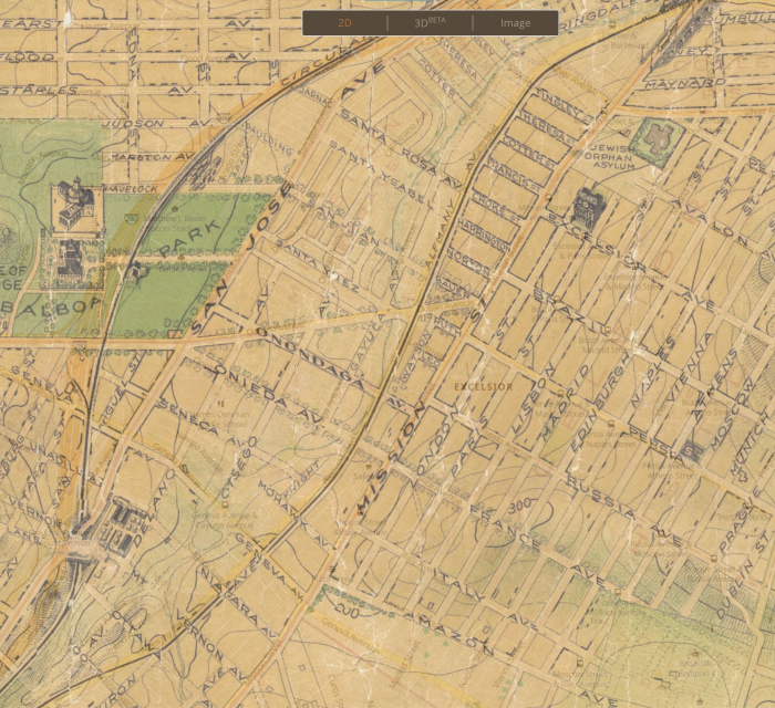
[[File:Screen Shot 2021-12-12 at 8.43.31 AM.png|thumb|center|700px|[https://www.davidrumsey.com/luna/servlet/detail/RUMSEY~8~1~3334~330001:The--Chevalier--Commercial,-Pictori The "Chevalier" ... Map of San Francisco. Chevalier, August, 1911]<br/>[https://davidrumsey.georeferencer.com/maps/b9acb9bc-449a-5f4c-8995-c0e54b73330a/view#123659182606 View in georeferencer] | [https://en.wikipedia.org/wiki/El_Camino_Real_(California) El Camino Real] | ||
[[File:Screen Shot 2021-12-12 at 8.43.31 AM.png|thumb|center|700px|[https://www.davidrumsey.com/luna/servlet/detail/RUMSEY~8~1~3334~330001:The--Chevalier--Commercial,-Pictori The "Chevalier" ... Map of San Francisco. Chevalier, August, 1911]<br/>[https://davidrumsey.georeferencer.com/maps/b9acb9bc-449a-5f4c-8995-c0e54b73330a/view#123659182606 View in georeferencer]]] | |||
[[Category:roads]] | [[Category:roads]] | ||
[[Category:places]] | [[Category:places]] | ||
[[Category:San Francisco]] | [[Category:San Francisco]] | ||
Latest revision as of 16:55, 12 December 2021
Mission Street is a north-south arterial thoroughfare in Daly City and San Francisco, California that runs from Daly City's southern border to San Francisco's northeast waterfront. The street and San Francisco's Mission District through which it runs were named for the Spanish Mission Dolores, several blocks away from the modern route. Only the southern half is historically part of El Camino Real, which connected the missions. Part of Mission Street in Daly City is signed as part of State Route 82 (SR 82).
